In Print: August 2024 Open Line articles
July 03 2024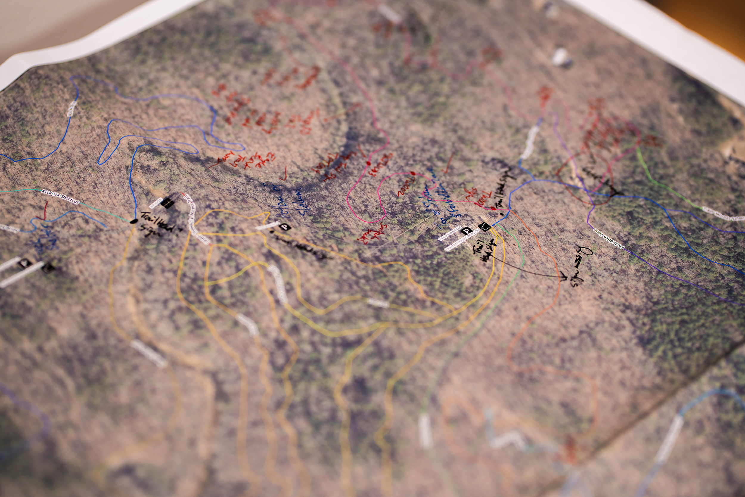
The following articles appeared in the August 2024 print edition of Open Line.
GIS meets EMS: How a map could save your life
Today, most of us could navigate practically anywhere by entering an address into our phone.
But what if you don’t have an address? And what if you’re looking for someone who isn’t quite sure where they are? And what if they’re in danger?
In fall 2022, the City of Auburn’s Emergency Communications team — tasked with getting police, fire and ambulance services to Auburn residents in an emergency — had to answer these questions in real time.
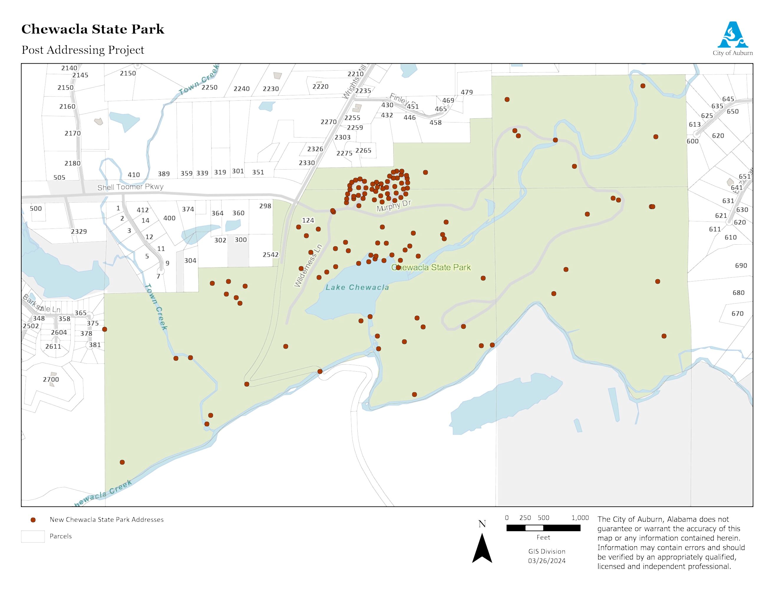
All 696 acres of Chewacla State Park has one address: 124 Shell Toomer Parkway in Auburn. When Communications Supervisor Trent Mitchell received a medical rescue call from someone hiking the park’s nearly 30 miles of trails, he had to be creative to get emergency responders more information than the location of the park entrance.
The caller reported they were “at the waterfall,” and the park rangers station said the caller was at the overlook. The 911 caller plotting system showed the caller on a trail in a different area of the park.
While the plotting system will sometimes show a large area in which the caller might be, this time, Trent said they got lucky — a tight circle pinpointed the caller’s location.
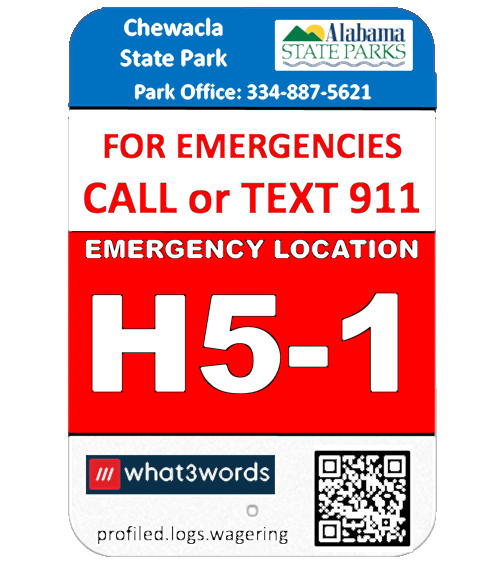
Instead of using traditional coordinates to let Auburn Fire know where the caller was, Trent used what3words, a system designed to identify any location within about 10 feet by putting a grid over the world and attaching three unique words to each box on the grid. Users can easily identify any location using the words in place of traditional latitude/longitude coordinates.
It took 17 minutes for emergency personnel to get to the caller, who was found near the overflow pipe that runs from the quarry into the state park (not at either of the park’s two waterfalls). They then began the challenging task of getting the caller out of the park, and the caller was life-flighted to a nearby hospital to receive the treatment they needed.
Auburn Fire and Emergency Communications met after the incident to review what went well and what could be improved. While communications received high praise for their work during the call, Trent saw gaps in the process. He regularly worked with the City’s GIS team to get new homes and other missing locations plotted on the City’s mapping system, and he wondered if they could do the same at Chewacla.
GIS had discussed a project to add sub addresses to golf courses throughout Auburn to provide more specific location points within the courses, but the project had been just an idea for some time. When Trent approached with a need at the state park, Deputy Chief Information Officer Christopher Graff saw “an opportunity to dig into the project.”
Christopher brought key stakeholders together, including representatives from Auburn Public Safety, Chewacla State Park and Central Alabama Mountain Pedalers (CAMP) — a volunteer group that helped construct and frequently uses the trails at the park.
"This was an opportunity to work together so we didn’t end up with something that left out pieces of the puzzle,” Christopher said.
The group started by gathering around an aerial image of the park and identifying key points. They talked through cabin and campground numbers along with street and loop names to ensure they had consistent, agreed upon identifiers for each one. They took note of the locations from which most people call park rangers either for help or with an injury, such as jumps for mountain biking along the trails.
After the meeting, GIS Technician Jennifer McKibben walked many of the trails to get a better understanding of the topography and to scope out potential map point placements. GIS then got to work adding those points to the City’s existing mapping system and updating an old CAMP trail map to account for additions, trail name changes and trails that are no longer maintained.
Along with the mapping piece of the project, local Eagle Scout Nathan King from Troup 12 in Auburn was already working with the park and CAMP to update trail signage. Communications Administrator Charlsie Little collaborated with Nathan and the park to determine what should go on the signs and where they should be placed. They decided to include multiple identifiers on each sign, including its what3words designation and a three-character combination they developed to identify where the sign was located within a grid map of the park. Twenty-two new signs were placed along the trails.
Another critical component of the project was determining the quickest route to reach someone within the park. While the main park entrance may be the fastest way to reach someone at the lake, it may be better to use an emergency access entrance in adjacent neighborhoods to reach someone on an isolated trail.
In the end, the team’s efforts resulted in more than 120 new sub-address points within Chewacla State Park. Now, rather than communications spending time trying to figure out the best way to describe a caller’s location, there are over 120 points to which they can quickly direct emergency responders. Auburn Fire has also incorporated the new map points and the updated trail map into its pre fire planning.
“During that training, they’re learning those points of interest, those addresses, those trails and how to access all of them,” Christopher said. “All of this data allows them to stay ahead of the curve.”
The project is already paying off. This April, a caller reporting a medical emergency used one of the new signs to convey their location. Auburn Fire was able to reach the caller in 10 minutes — seven minutes faster than a 2021 medical call in the same area.
The team has plans to help improve response times by expanding the project to other areas of town, including City parks, golf courses, the Kreher Preserve and Nature Center and Jordan-Hare Stadium. By doing so, first responders will not only be able to locate 911 callers faster, but Public Safety will also be able to use call data to identify problem areas within a park or facility that could be mitigated.
You can explore the newly added points at Chewacla State Park by viewing the COA Map at auburnalabama.org/maps. You can also find a location’s what3words designation via the what3words app or by visiting what3words.com.
Hidden gems: Auburn’s small parks & trails
July is Parks and Recreation Month, and the theme this year is “Where You Belong,” celebrating the ways our Parks and Rec pros foster a sense of belonging in our community.
One of the ways we do that is by providing top-tier outdoor spaces where the community can gather to enjoy nature and time with each other. So, we’re celebrating this year’s theme by kicking off a series about our small parks and trails.
First up — Sam Harris Park!
Located at 850 Foster Street, there’s a lot to do at this seemingly small park. The park features a playground, two pavilions — which are available for rent or to just enjoy some time in the shade — and an outdoor basketball court. Three years ago, we added a new walking trail that is just over a mile, extending from the back of the park to the fields on Shug Jordan Parkway and CARE Humane Society. If you haven’t been yet, we invite you to take a stroll!
Learn more about all Auburn Parks and Recreation has to offer by following @COAParksAndRec on Facebook and Instagram.
National Night Out set for Aug. 6
Auburn Public Safety invites the Auburn community to celebrate National Night Out on Aug. 6! This year’s event will be held at the field behind Duck Samford Stadium (1623 E. Glenn Ave.) from 5:30-7:30 p.m.
The evening will feature free food and family-friendly fun for all ages including representatives from local organizations with free community resources, a meet and greet with Auburn school resource officers, a Touch-a-Truck display, a K9 demo, photo ops with Sparky the Fire Dog and McGruff the Crime Dog, face painting and more!
Keep an eye out for more info by following Auburn Public Safety @COAPublicSafety on Facebook, Instagram and X.
End-of-Summer Pokémon Party
“Gotta catch us all” saying goodbye to Summer 2024 with a special Pokémon themed party at the Auburn Public Library! The event will be held on Saturday, Aug. 3, from 2-3:30 p.m. Build your team while we play games, make crafts, host activities and enjoy yummy snacks inspired by the wildly popular pocket monsters.
This event is free and open to the public. For more information, email libraryevents@auburnalabama.org or call (334) 501-3296.
Itty Bitty Auburn Scavenger Hunt
It's time to break out the thinking caps and magnifying glasses for the Itty Bitty Auburn Scavenger Hunt!
Beginning Aug. 1, participants can pick up a worksheet for the scavenger hunt at any Parks and Recreation facility. It will also be available at auburnalabama.org/parks or on the Auburn Parks and Recreation Facebook page.
The worksheet will feature 20 itty-bitty sites in various locations around Auburn. Once you’ve figured out the location, head there to find a clue. Once you’ve visited each of the 20 sites and collected the clues, they will reveal a special phrase that you will need to log your win!
All participants must enter the secret phrase by registering for Itty Bitty Auburn at auburnal.myrec.com by Saturday, Aug. 31, at 11:59 p.m. Those who have the correct phrase will be entered into a grand prize drawing. Winners will be announced and contacted on Sept. 6.
Summertime watering tips from the Water Works Board
It’s hot out there. And when the temperatures rise, so does the demand on our water sources. The Water Works Board of the City of Auburn has a few pointers to help us all follow efficient practices for irrigation and outdoor watering. Try these tips to help conserve water:
- Don’t overwater your lawn. Generally, lawns only need watering every five to seven days during the summer.
- Don’t water sidewalks, driveways or other paved areas.
- Avoid watering during the middle of the day to avoid unnecessary water loss because of evaporation. Water before 8 a.m. As a general rule, the earlier, the better!
- Check irrigation systems on a regular basis to ensure the system’s parts are not damaged or broken. Many irrigation systems use about 1,000 gallons of water an hour!
- Install rain sensors and/or moisture sensors on irrigation systems to eliminate unnecessary watering during rainy periods.
- Don’t leave sprinklers or hoses unattended. Use a timer to remind you to turn the water off.
- Use xeriscaping, or practices that minimize water usage. Get more info about xeriscaping from the Alabama Cooperative Extension Service’s website, aces.edu.
- Consider rainwater harvesting. Consider collecting rain using rain barrels, etc. that can be used for outdoor watering. Note that rain barrels can collect pollutants and bacteria from roofs, animals, etc. This should be considered when using rain barrels for edible plants. Water from rain barrels should never be used for human consumption.
- Increase your lawn mower blade height. A higher-cut lawn will encourage deeper-growing roots and will result in better soil moisture retention.
- Mulch effectively around all plants, trees and shrubs. Mulching helps soil retain moisture and controls weeds.